|
| PACIFIC CREST TRAIL FLORA PROJECT SAN GABRIEL MOUNTAINS |
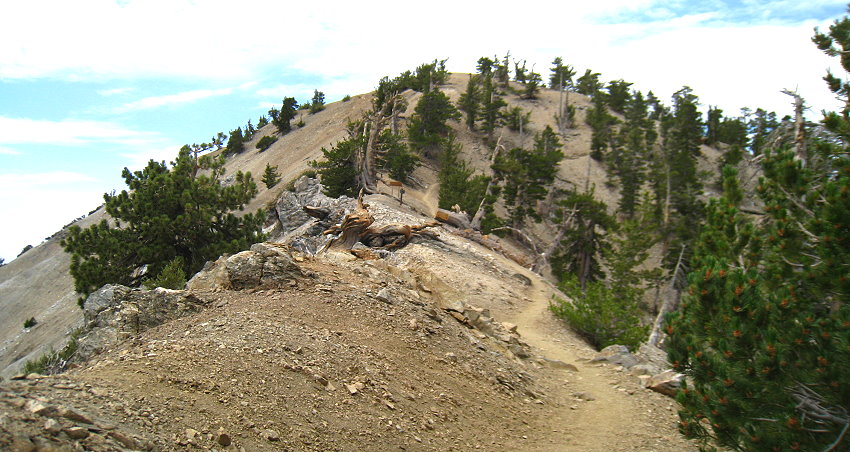
The photo above shows the highest point of the Pacific Crest Trail in the San Gabriel Mts just below the summit of Mt. Baden-Powell. The San Gabriels section is just a small part of the Pacific Crest Trail which runs 2600 miles from the Mexican border to the Canadian border. In April, 2013, I decided to begin recording and documenting in photographs the flora of the trail. This is intended to be a multi-year project which will cover the entire distance in different years and at different times during the year to compile as complete and accurate a flora list as possible. I have been accompanied on a number of segments of the trail by Tom Chester, Jim Adams, Walt Fidler, and Adrienne Ballwey, and have been assisted particularly in identifying species by Tom Chester and RT and Shaun Hawke. In the east the San Gabriel Mountains section of the Pacific Crest Trail begins at Interstate 15 in the Cajon Pass and extends approximately 101 miles to Soledad Canyon Road in the west. From its beginning near the jct of I-15 and SR-138, it climbs over some low ridges affording one lovely views of the Mormon Rocks and the multiple train tracks of the Burlington Northern and Santa Fe and the Union Pacific Railroads, then ascends and travels along an open ridgeline before dropping into Swarthout Canyon and crossing Swarthout Canyon Road (3N28) into Lone Pine Canyon. From there it winds up and along Lytle Creek Ridge through a chamise, oak and ceanothus chaparral, crossing Forest Road 3N29, and basically paralleling the Sheep Creek Truck Trail (3N31) past Gobbler's Knob Campground and looking down into Stockton Flats and over at the windswept summit of Mt. Baldy, and then continuing along near the Blue Ridge Truck Trail (3N06) past Wright Mountain, Guffy Campground and Blue Ridge Campground to the Angeles Crest Highway at Inspiration Point. Along this section of the trail one passes from San Bernardino County into Los Angeles County, and there are some lovely views down on the mountain community of Wrightwood. From Inspiration Point at 7360' it is a short 4-mile hike past the Grassy Hollow Visitor Center to Vincent Gap, where the trail crosses the ACH and ascends from 6585' up numerous switchbacks to pass just below the 9407' summit of Mt. Baden-Powell. The short walk to the summit is not to be missed as one has fantastic views in every direction. The trail continues along what John Robinson refers to as the Middle High Country, where late spring and summer are colored by some great wildflower displays, passing near and just below the summits of Mt. Burnham, Mt. Hawkins, Throop Peak and Mt. Islip, the junctions of the trails north to Dawson Saddle and south to Crystal Lake, and historic Little Jimmy Campground, before sliding down to the Islip Saddle parking area at 6700'. After a brief pause to catch one's breath at that elevation, the hiker ascends once again and passes just below the 8214' summit of Mt. Williamson, then rapidly descends, crossing the ACH and passing along the manzanita-covered spine of Kratka Ridge to Eagle's Roost at 6600'. At this point the higher elevations of the San Gabriels are left behind as one drops into the shady recesses of Little Rock Creek and Cooper Canyon (trail section closed due to the endangered yellow-legged frog), crosses the Burkhart Trail below Buckhorn Campground, and then winds up again to the ACH at Cloudburst Summit (7018'). From this point the trail slowly descends through a more or less open piney woods, crossing the ACH several times, before arriving at the junction of Santa Clara Divide Road (5885'). From Mt. Baden-Powell to this point the trail is both the Pacific Crest Trail and the boy scouts' Silver Moccasin Trail, but here the two trails diverge, the Silver Moccasin heading in a southwesterly direction to near Mt. Wilson and then down the Arroyo Seco to Pasadena, and the Pacific Crest Trail bearing more northwesterly to the Sulphur Springs area, Pacifico Mountain and Mill Creek Summit on the Angeles Forest Highway. From Mill Creek Summit the trail continues parallel to Mt. Gleason Road (3N17) and passes near the summit of Mt. Gleason. After heading primarily westward, the trail makes a right turn and proceeds almost due north, dropping first to North Fork Saddle and then down to its meeting with Soledad Canyon Road. Over the course of its 101 miles it passes through desert terrain, intimate canyons, and high mountain ridgelands, and gives any hiker who is interested a rich and varied view of the diverse flora of the San Gabriels. UPDATE 11/19/21: Now that the Mt. Gleason road is open again at long last, it is my intention during the spring and summer of 2022 to renew my photographic investigations of the San Gabriel sections of the Pacific Crest Trail, in particular the ones east of Mt. Gleason. And this time I will be fortunate to have with me Orlando Mistretta's wonderful Field Guide to the Flora of the San Gabriel Mountains, a work that he has been engaged in for many years, and which was sorely needed. Of course, it appears that as of November, 2021, a very large section of the Angeles National Forest remains closed because of the Bobcat Fire including the Pacific Crest Trail all the way from Three Points to the intersection with the Dawson Saddle Trail. There is no telling how many years will pass before this area opens again so this will have a substantial impact on this project. The links below are listed by section going west to east although they were not necessarily done in this exact order. A master list section by section of the flora observed along the San Gabriel Mountains portion of the Pacific Crest Trail may be found here. |
| Copyright © 2014 by Michael L. Charters. The photographs contained on these web pages may not be reproduced without the express consent of the author. Comments and/or questions may be addressed to: mmlcharters[at]gmail.com. |